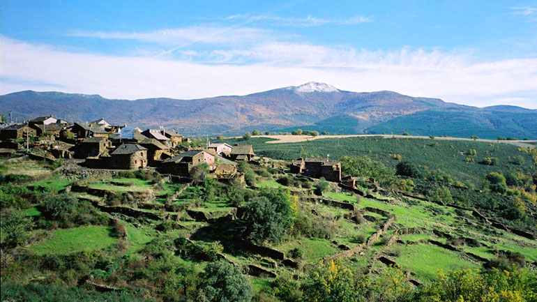
Deporte en la Ruta de los Pueblos Negros
El Blog de la Ruta de los Pueblos Negros

La Muralla China
- Detalles
- By Rafa Martí
- Visto: 4602
La Arquitectura Negra de Guadalajara es muy conocida por sus peculiares construcciones con la pizarra que ofrece esta parte de la Sierra Norte: cobertizos, casas, tainas (parideras, majadas), muretes, plazas, etc.

CM-1 Pico Ocejón por Majaelrayo
- Detalles
- By Jorge Cruz
- Visto: 2850
SENDA (CM-1) Ascensión al Pico Ocejón desde Majaelrayo.
DISTANCIA: 13 Km.
DESNIVEL POSITIVO: 940 m.
DESNIVEL NEGATIVO: 940 m.
MÁXIMA ALTURA: 2.048 Pico Ocejón
MÍNIMA ALTURA: 1.184 Majaelrayo
HORARIO EFECTIVO: 5h
CARTOGRAFÍA IGN
Huso: 30 / Banda: T
Hoja: 459 / Cuadrícula: 2
DESCARGAR TRACK (GPX)>>
Ver instrucciones para la descarga de Tracks en formato GPX>>
DESCARGAR TOPOGUÍA CON MAPA Y PERFIL (PDF)>>
LA VÍA DE ASCENSO AL PICO OCEJÓN MÁS UTILIZADA POR LOS MONTAÑEROS.

Camino de Matallana PR-GU-02
- Detalles
- By Jorge Cruz
- Visto: 1352
PR-GU 02 CAMINO DE MATALLANA.
- DISTANCIA: 11,5 Km.
- DESNIVEL POSITIVO: 640 m.
- DESNIVEL NEGATIVO: 410 m.
- MÁXIMA ALTURA: 1.240 Cuchillar del Asomante
- MÍNIMA ALTURA: 930 Río Jarama
- HORARIO EFECTIVO: 3h40´
CARTOGRAFÍA IGN
Huso: 30 / Banda: T
Hoja: 459 / Cuadrícula: 3 y 4
Ver instrucciones para la descarga de Tracks en formato GPX>>
DESCARGAR TOPOGUÍA CON MAPA Y PERFIL (PDF)>>
MATALLANA, ARQUITECTURA NEGRA EN ESTADO PURO.

El Barranco de El Jarama PR-GU-04
- Detalles
- By Jorge Cruz
- Visto: 1624
SENDERO (PR-GU-04) EL BARRANCO DE EL JARAMA.
- DISTANCIA: 18,5 Km.
- DESNIVEL POSITIVO: 882 m.
- DESNIVEL NEGATIVO: 640 m.
- MÁXIMA ALTURA: 1.314 Pedriza Matacuras
- MÍNIMA ALTURA: 972 Río Jaramilla
- HORARIO EFECTIVO: 6h
CARTOGRAFÍA IGN
Huso: 30 / Banda: T
Hoja: 459 / Cuadrícula: 1 y 3
Ver instrucciones para la descarga de Tracks en formato GPX>>
DESCARGAR TOPOGUÍA CON MAPA Y PERFIL (PDF)>>
EL CARDOSO DE LA SIERRA ES UN PRECIOSO RINCÓN DE LA PROVINCIA DE GUADALAJARA.